
Transcultural (historical) research necessitates the integration of both macro and micro levels of research and analysis and emphasizes the dynamic and interactive character of its research objects in their historical and geographical dimension (‘How Histories make Geographies’ and vice versa).1The interdisciplinary, interconnected HGIS-projects located in Heidelberg share a common vision: They facilitate research in the humanities by e.g. (semi-)automatic, it-enhanced processing of information, by adding modes of spatial search in heterogeneous data, by supporting visualization of patterns formed by spatio-temporal data or a mash up of data from different sources of a different kind. Thereby they ultimately foster the researcher to formulate new questions and theses and eventually find some answers by experimenting in a sort of ‘humanities lab’. Only close collaboration of geographers, historians and computer scientists can ensure that new digital tools and methodologies do not stay outside the framework of everyday scientific work in the humanities.
The online gazetteer ‘Orbis Latinus Online’ (OLO) is in its contents based on the three-volume, 1972 edition of the Latin-German-dictionary of the same name (‘Großausgabe’)2 and published as a data base in cooperation with the Bayerische Staatsbibliothek Munich (BSB).3The project contributes to the ongoing interdisciplinary Heidelberg HGIS-projects RIgeo.net and uses the geocoder GeoTWAIN, which is part of the Heidelberg Research Architecture (HRA, Cluster of Excellence ‘Asia-Europe in a Global Context’), in addition to further funding mentioned above. The OLO has currently reached beta-status and will be made accessible to the public in 2012.
The OLO provides coordinates to every Latin place name listed in the Orbis Latinus4, additional contextual information missing in the print version as well as links between the entries and different cross-references. The user can, for instance, search for latin place names or their modern equivalents by using a multilanguage webfrontend (php/mySQL). The place names are stored in a PostgreSQL db to use the advanced GIS-functionality of PostGIS. The original print version provided by the Münchener Digitalisierungszentrum (MDZ) is linked and the place is shown on Google Maps (later: Open Street Map) to give the user the opportunity to verify the entry. A web service based on XML-RPC is currently tested. Due to copyright restrictions, this involves as by now just the BSB and RIgeo.net. The basic gazetteer services are accompanied by a kind of ‘geo-wiki’ which provides commentaries and alternatives to the shown locations or the assignment of the Latin place names to the modern ones (or vice versa). The backend of the OLO consists of several parts such as a tool for parsing the ocr-results and ‘cutting them up’ according to the needs of the relational data base, a user management as well as a versioning system.
At first sight, it seems to be a quite simple and one-off task to provide the coordinates, but the design of the database proved not to be without challenges, – a discussion of which will be the main topic of our poster. The first semi-automated georeferencing of the places added from the print version was made via Google Maps. Most geocoders like Google Maps provide satisfactory results merely for the main settlements, since Google Maps provides just the coordinates of the ‘most important’ place. This can but must not necessarily be the searched location (e.g. a town like ‘Neustadt’ exists more than 50 times in the world). Therefore besides establishing a connection to additional gazetteers and georeferencing-services with advanced structured information, a collaborative multi-user-environment with rights-management to add, correct and comment on the entries was needed.
Registered users can now provide alternative modern day place names and/or coordinates and comment on their choice, the level of probable historical correctness of their entries/of their entry, the time span for which their equivalent is valid and on the sources they have used. The search option for alternative/additional coordinates uses the functionality of a web based tool of the HRA called GeoTWAIN.5 Among other options, it offers a quick visual search for coordinates including plausibility checks. During its interview-like search, a range of all coordinates is presented to the user, all of them fitting to given place names worldwide in all languages based on the search in different gazetteers (UTF-8), especially including the Getty Thesaurus of Geographical Names (TGN, which was licensed by the HRA).
To prevent vandalism and obvious incorrect data, new entries will be reviewed by the editors. The new coordinates or place names submitted are presented parallel to the older ones, open for rates and comments by fellow users. The entries on the results page are arranged according to their rating. Contributors are shown by full name (if they want to), so that credits can be assigned to individual researches (and maybe the context of research they used the OLO for).
Together with GeoTWAIN and RIgeo.net the OLO is one of the various interconnected services of a virtual research environment, the ‘gis-toolbox’, envisioned and realized by the Heidelberg HGIS-research which is being developed with the aim to provide researchers with a set of databases and tools, e.g. to facilitate the analysis/mapping/combining of itineraries of medieval nobility and thereby define the spatial dimension of power and control beyond simplified linear boundary lines.
Project coordination
Dr. Kilian Schultes, Stefan Geißler, Jun Zhu: History Department, Heidelberg University in cooperation with Prof. Dr. Bernd Schneidmüller
Project members
Konrad Berner, Arina Chithavong, Matthäus Feigk, Philipp Franck, Anuschka Gäng, Peter Gietz, Timo Holste, Lukas Loos and Thomas Seitz
Project financing
Mostly a private initiative, Heidelberg University, Cluster Asia-Europe in a Global Context; Prof. Dr. Bernd Schneidmüller, History Department, Heidelberg University & RIgeo.net, “Frontier”-project, Heidelberg University (Prof. Dr. Alexander Zipf/Dr. Kilian Schultes in cooperation with Prof. Dr. Paul-Joachim Heinig, Akademie der Wissenschaften Mainz, Deutsche Kommission für die Bearbeitung der Regesta Imperii)
Project cooperations
Heidelberg Research Architecture (HRA) Cluster Asia-Europe in a Global Context, History Department – Universität Heidelberg
Project presented by Stefan Geißler/Dr. Kilian Schultes
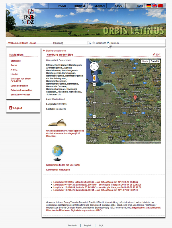
Figure 1
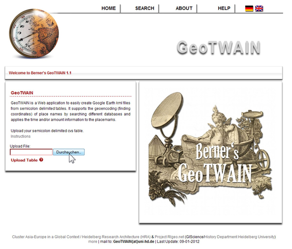
Figure 2
References
Appadurai, A. (2011). How Histories make Geographies. Transcultural Studies 1. Available from: http://archiv.ub.uni-heidelberg.de/ojs/index.php/transcultural/article/view/6129. [Accessed 22 Jan 2011].
Döring, J., and T. Thielmann, eds. (2009). Spatial Turn: Das Raumparadigma in den Kultur- und Sozialwissenschaften. 2nd ed. Bielefeld: Transcript.
Graesse, J. G. T., F. Benedict, and H. Plechl, eds. (1972). Lexikon lateinischer geographischer Namen des Mittelalters und der Neuzeit: Großausgabe, bearbeitet und herausgegeben von Helmut Plechl unter Mitarbeit von Sophie-Charlotte Plechl, 3 vols. Braunschweig: Klinkhardt & Biermann.
Knowles, A. K., A. Hillier, and R. Balstad (2008). Conclusion: An Agenda for Historical GIS. In A. K. Knowles and A. Hillier (eds.), Placing History. How Maps, Spatial Data, and GIS are Changing Historical Scholarship. Redlands, CA: ESRI Press, pp. 267-274.
Owens, J. B. (2007). Toward a Geographically-Integrated, Connected World History: Employing Geographic Information Systems (GIS). History Compass 5(6): 2014-2040.
White, R. (2010). What is Spatial History? Spatial History Lab: Working paper [online] (Feb.). Available from: http://www.stanford.edu/group/spatialhistory/cgi-bin/site/pub.php?id=29. [Accessed 29 Dec 2010].
Notes
1.Döring et al. 2009; White 2010; Appadurai 2011; see also Knowles et al. 2008 and Owens 2007
2.Graesse et al. 1972. The less extensive one-volume edition from 1909 is online since 2000 as a text-only-html-website and has attracted some 370.000 visits: http://www.columbia.edu/acis/ets/Graesse/contents.html [Accessed 12 Feb 2012].
3.The BSB is the owner of the online publication rights. The pdf-version of the 1972-Orbis Latinus is published here: http://daten.digitale-sammlungen.de/~db/0005/bsb00050912/images/index.html [Accessed 12 Jan 2011]
4.Currently 140.000 Latin place names and 40.000 modern place names.
5.http://geotwain.uni-hd.de [Accessed 24.3.2012].